The Sankey Street gateway scheme aims to improve our town centre. Sankey Street and Hilden Square will be a welcoming space that is safer and more attractive. It will provide better routes for all people accessing the town centre along this route.

The proposals include new and upgraded surfacing of the footway and carriageway, more greenery and planting, better facilities for pedestrians and cyclists, and improvements for buses. The scheme is part of a Sustainable Travel programme, which is part of the council’s Town Deal programme announced in 2022 and funded by UK government.

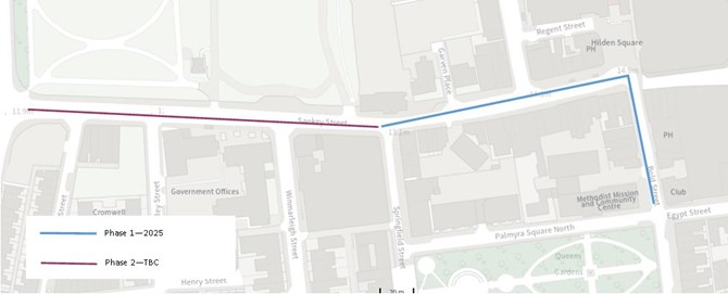
The long-term vision is to look at the whole length of Sankey Street from Bold Street to Crosfield Street. This consultation is for Phase 1: Bold Street to Springfield Street.

Phase 2 will be consulted on when funding becomes available.

Why is Sankey Street gateway being improved?

Sankey Street is a key gateway

Sankey Street is a key gateway between the town centre pedestrianised areas and the Town Hall and Palmyra Quarter and is home to many businesses, shops and historic buildings. Hilden Square is a public space next to the Golden Square shopping centre where people sit, gather and walk around.

Supporting the town centre

Like many other towns across the country, Warrington Town Centre has faced a number of challenges such as a move to online shopping. Despite this, there is a good variety of shops, restaurants and services on offer, and the successful Time Square and Warrington Market development is bringing more people into the Town Centre. We need to build on this success to help make the Town Centre a vibrant and attractive space and a place for our residents and businesses to be proud of.

Making Sankey Street / Hilden Square more people focused

In recent years traffic levels on Sankey Street and within the wider Town Centre have reduced, with more through traffic now using routes around the edge of the town centre such as Parker Street and Midland Way. However, Sankey Street and Bold Street still attract some through traffic movements and the streetscape is dominated by a wide carriageway, with few crossing points for pedestrians, narrow footways in places and an unattractive environment for cyclists.  The footway and carriageway is worn and poor quality in places and the route does not provide a pleasant or attractive connection to the Palmyra Quarter, Parr Hall, Pyramid or the Town Hall. Despite being a key bus route into the Town Centre, when passengers alight they enter an unattractive place.  Whilst Hilden Square is a key public space, motorised vehicles still move and park through the space conflicting with people gathering and walking around.
Scheme overview

Objectives and benefits

Town

Creating a positive first impression at one of Warrington’s key arrival points

Supporting the economic growth of the Town Centre

More people using buses, walking, wheeling and cycling 

People

Providing a safer and more attractive street for walking, wheeling and cycling 

Making the air cleaner

Travel

Providing greater priority to pedestrians and buses

High-quality public realm, including widened footways, narrowed carriageway, more frequent informal crossings, attractive materials

Scheme Details

Hilden Square/Bold Street

Key Features

  • Safer more welcoming environment for pedestrians with removal of all traffic in Hilden Square
  • Addition of informal crossing point from Hilden Square to Sankey Street and replacement of current crossing outside Waterfields Bakery
  • Inclusion of a segregated Westbound cycle lane
  • Planting / features to help segregate users and make area more attractive
  • Materials on Bold Street to match lower section of Bold Street
  • Designated taxi waiting on Bold Street
  • Removal of fencing and Utility boxes on edge of Hilden Square
  • Revised restriction to restrict traffic to buses and taxis between 10am to 4pm
  • Removal of unnecessary street clutter
  • Inclusion of a segregated Bi-directional cycle lane
Image
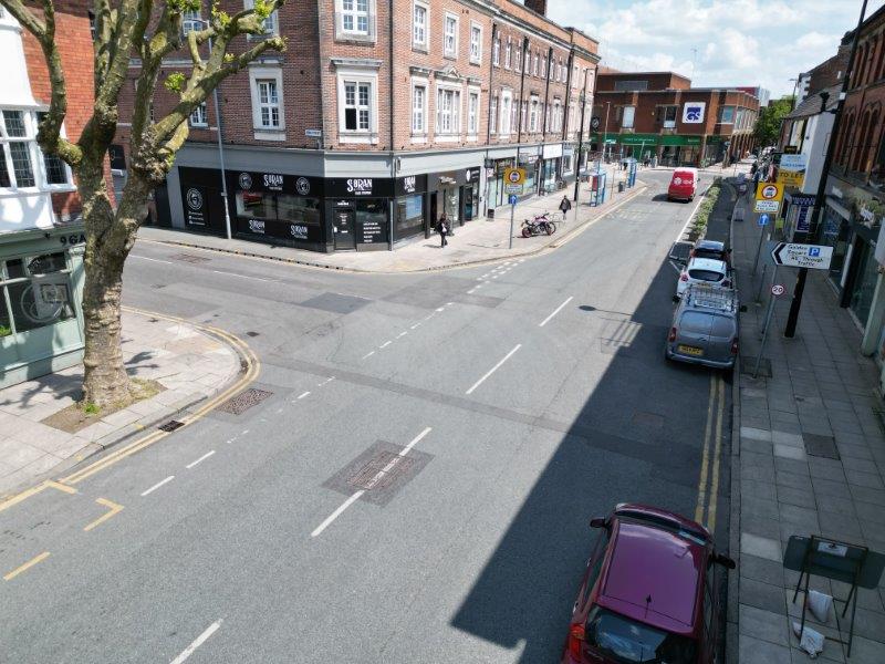
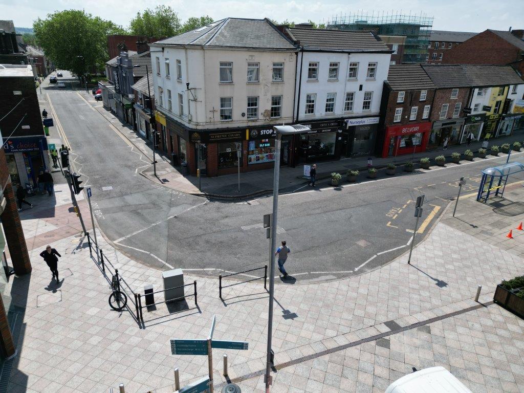
Sankey Street - Hilden Sq - pre improvements

Current view of Hilden Square

Image
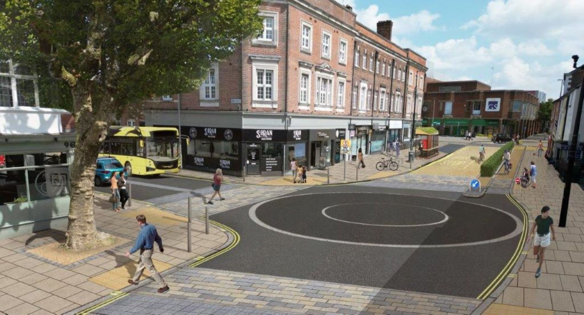
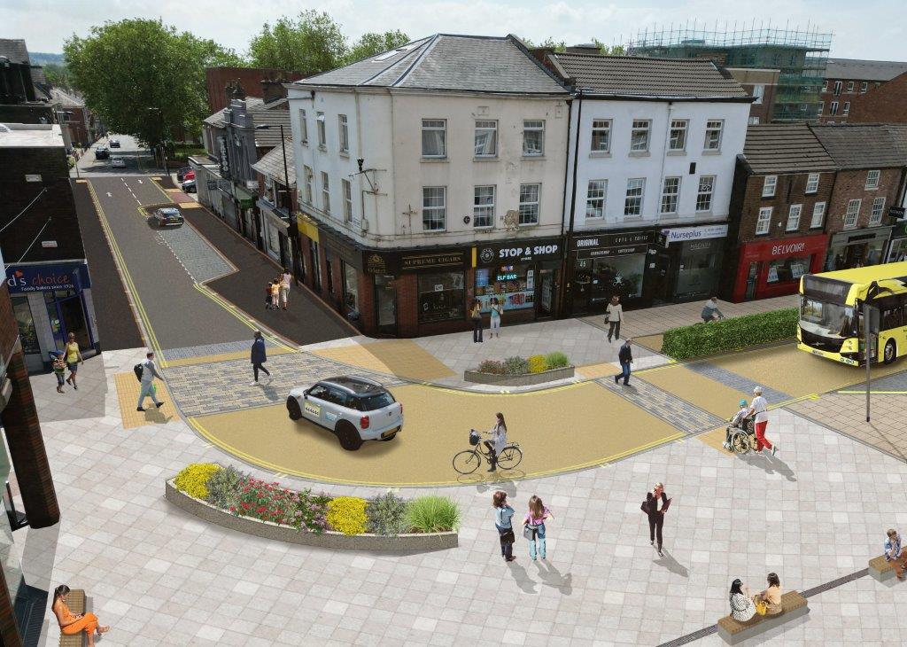
Hilden Square - proposed

Proposed view of Hilden Square

Legh Street Junction

Key Features

  • Loading time restrictions implemented on Sankey Street and Bold Street eastbound beyond Legh Street. Buses, taxis and cycles permitted at all times
  • Change of surfacing and signage to emphasise the gateway into different streetscape east of Legh Street
  • Roundel feature acting as informal junction to slow traffic movement
  • Additional crossing points
  • Planting / features to help segregate users and make area more attractive
  • Improved footway and carriageway surfacing
  • Wider footways
  • Westbound segregated cycle lane
Image
Sankey Street - Legh St junction before

Sankey Street - Legh St junction current view

Image
Legh st junction - proposed

Legh street junction - proposed

Sankey Street

Key Features

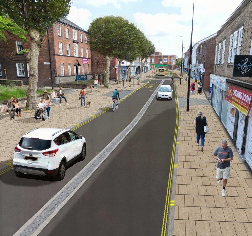
  • Wider footways
  • Introduction of seating
  • Improved footway and carriageway surfacing
  • Central flush dividing strip to make traffic movements safer
  • Removal of parking bays
  • Review of crossing facilities around junction of Springfield Street and potential replacement of formal crossing point with two new informal crossings, subject to phasing of improvements along Sankey Street
Image
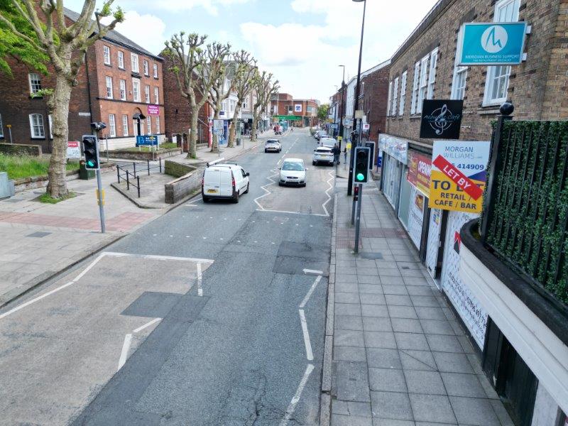
Sankey Street - current view

Sankey Street - current view

Image
Sankey St - proposed

Sankey Street - proposed

Consultation - have your say

We will be consulting on the Sankey Street Gateway until 13 December 2024. Please fill out our survey to tell us what you think of the plans.

In person

Golden Square Shopping Centre, near Next

  • Thursday 21 November - 3pm to 7pm
  • Saturday 23 November - 9am to 2pm

Online

Complete our survey to tell us what you think of the plans


Frequently asked questions

What is proposed?

The Sankey Street gateway scheme has the following features:

  • Widening of footways
  • Introduction of informal crossings
  • Refreshed street materials
  • Reduction of traffic through Sankey Street and Bold Street from Legh Street
  • Removal of all traffic in Hilden Square
  • Introduction of cycle lane
  • Introduction of seating
  • Introduction of planting
Why is it being proposed?

The Sankey Street gateway scheme aims to improve our town centre. Sankey Street and Hilden Square will be a welcoming space that is safer and more attractive. It will provide better routes for all people accessing the town centre along this route.

The proposals include new and upgraded surfacing of the footway and carriageway, more greenery and planting, better facilities for pedestrians and cyclists, and improvements for buses.

The key objectives of this scheme are to:

  • Improve access to the town centre by active modes.
  • Improve safety for all road users by segregating modes and reducing conflict
  • Improve public realm, making the corridor a nicer place to pass through and dwell in
How does the scheme fit with Warrington Borough Councils policies?

The scheme is part of the council’s approach to improve the town centre, making it a more vibrant and attractive place and make it more accessible to all. The principles of the scheme were approved in the Warrington Town Centre Supplementary Planning Document in

The scheme and its objectives also support various polices and strategies contained in other council documents including:

How will this scheme be funded?

This project funded by The Town Deal which is a government grant.

It is part of a number of projects in the Town Centre funded this way.

Warrington Town Board is a group of business, political, leisure, cultural, community and education leaders. In February 2022, our Town Deal took a huge step forward, with confirmation that the £22.1m funding for all seven projects was given the go-ahead by The Department for Levelling Up, Housing and Communities (DLUHC). One of these seven projects is a Sustainable Travel Programme which the Sankey Street Gateway scheme falls under.

Why isn’t this money being spend on something else? E.g. filling potholes

This is grant funding awarded specifically for this scheme. If the scheme doesn’t go ahead the money would need to be returned.

Why aren’t you doing the whole of Sankey Street?

The long-term vision is to improve all the way along Sankey Street from Parker Street down to Bold Street. We do not currently have enough funding for the whole stretch.

This first phase of works will take us from Springfield Street to Bold Street.

We will consult on Phase 2 when funding becomes available.

Image
Sankey street phases
How will it improve active travel?

Walking and Wheeling

The scheme creates wider footways on both sides of Sankey Street. It also removes traffic entirely from Hilden square. This will make it a safer and more welcoming environment.

There will be the addition of benches across the area as places to rest.

Cycling

A westbound segregated contra flow cycle lane will be added between the top of Bold Street and Legh street. This will allow those coming through the Town Centre to continue their journeys out of the town centre.

In an eastbound direction the road environment will be more attractive for cyclists with slower speeds and fewer motorised vehicles east of Legh Street

How will drivers be affected?

There are no changes to access between Springfield Street and Legh Street.

The section of Sankey Street from Legh Street round to Bold Street will be restricted to buses and taxis only. With loading will be allowed in designated areas at restricted times.

The times for loading are proposed to between 4pm and 10am to line up with other areas in the Town Centre.

No access will be allowed by vehicles into or through Hilden Square (with the exception of emergency access)

Regent Street will become two way – with a turning head at the Hilden Square end.

There will be two-way access at the southern section of Bold Street from Palmyra Square allowing access to the loading and parking areas at the back of properties on Sankey Street.

How will the restrictions be enforced?

Cameras are not being installed as part of the scheme.

Enforcement would be by the police.

Why are some road markings and road features being removed?

Although traffic levels on Sankey Street have reduced in recent years and the proposed scheme will reduce traffic levels further, the carriageway is wide and the street is dominated by motorised traffic.

The proposed design seeks to change the way Sankey Street operates by reducing the dominance of motor vehicles, primarily through lower speeds and encouraging drivers to behave more accommodatingly towards pedestrians and cyclists. This approach is called ‘informal streets’ and has been used widely across the UK, including on Academy Way in Warrington to provide a crossing point between the multistorey car park and Time Square. The Warrington Town Centre Supplementary Planning Document outlines the Council’s approach to reducing the dominance of motor vehicles through the use of informal streets in key areas of the Town Centre.

By removing some road markings, this indicates that Sankey Street is not a major highway, and that drivers, pedestrians and cyclists must be respectful of each other.

There will still be a kerb line on either side of the carriageway and dropped kerbs with tactile paving at crossing points, so the street can be navigated by people with sight loss.

What is a roundel and what do they look like?

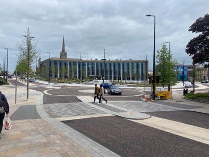
A roundel is a type of informal unmarked junction that is commonly used when designing ‘informal streets’ (please see explanation of ‘informal streets’ above).

It is not a gyratory or roundabout and the give way right rule does not apply. The roundel should be treated as an unmarked junction, where no one has priority and drivers should approach them slowly, smoothly and give way to other road users including pedestrians and cyclists.

Examples of Roundels and their locations are provided below.

Image
Roundel - Preston
What changes are proposed to the crossings on Sankey Street?

We have surveyed use of the formal crossings and found that people are more often crossing without pressing the button or waiting for the green man. To reduce street furniture and improve accessibility across the whole area, we are proposing to remove the formal controlled crossings.

The formal crossing will be taken out outside of Waterfield’s Bakery. It will be replaced with a number of informal crossing (similar to on academy way outside of Cineworld).

We are looking at reviewing the formal crossing outside of Garvin Place and either relocating further towards the Gateway or replacing with an informal crossing.

There will be more crossing facilities to assist users in their journey across the whole route.
 

When will it be done and how long will it take?

Currently exact dates are unknown for the construction of this scheme. We are aiming for construction to start late Spring 2025.

It is envisaged that the construction will be around 5 months.

Will there be road closures/diversions?

Yes, sections of Sankey Street will need to be closed during works.

The scheme will be delivered in sections and Warrington Borough Council will notify users in advance of closures and diversions.

We will engage with stakeholders, businesses and residents in advance to minimise disruption.

Will the proposals / scheme impact on trade for businesses?

Ultimately the scheme aims to make Sankey Street a more desirable location for people to be and therefore wants to support the local economy.

We are encouraging businesses to put forward their views by completing the survey.

What is the cost of the scheme?

The budget for the scheme is or £1.5m

The funding is a government grant through the Town Deal and is specifically for this project. If a scheme was not to be delivered, we would have to return the funding. 

Are you planning on making changes to any parking?

There currently are around 4 short stay spaces that are proposed to be removed outside Garvin place. This is to reduce the number of vehicles in the area, provide wider footways for pedestrians and make Sankey Street a more open and welcoming space.

Ample parking is available nearby on-street on Palmyra Square and Egypt Street with off street parking at Golden Square and the Town Hall car park.

There are disabled bays on Winmarleigh Street and Palmyra Square and in both nearby off-street car parks.

Will emergency services be able to access properties and businesses?

Access for emergency services will remain.

Hilden Square will have drop bollards that the emergency services can drop down should they need to access this area.

What are the next steps?
  • Consultation closes 13 December
  • Review responses - December 2024
  • Review feedback and update designs – January/February 2025
Image
Funded by UK Government
20 November 2024